

Table of Contents
What Clouds Have the Greatest Turbulence: A Guide to turbulence and clouds
There’s something about clouds that always fascinates us. They come in so many different shapes and sizes, and each one seems to have a personality of its own. But what you may not know is that these beautiful creatures can also be quite dangerous. In this article, we’ll discuss turbulence and the different types of clouds that are most likely to cause it. We’ll also provide some tips on how to stay safe when flying in turbulent skies. So whether you’re a cloud enthusiast or just looking for information about turbulence, we’ve got you covered!
Cloud types and where to find them
Turbulence is caused by atmospheric conditions, and there are three primary types of clouds that can create it: cumulonimbus, cumulus, and stratus. Each of these has a different level of turbulence potential, depending on its size and shape.

The most likely to create turbulence are cumulonimbus clouds. They are large, convective clouds that can grow up to 60,000 feet in the sky. They often form in areas of low pressure and high humidity, such as near thunderstorms. These conditions make them unstable and more likely to produce strong updrafts and downdrafts that can cause turbulence.
Cumulus clouds are smaller than cumulonimbus clouds but can still cause turbulence. They are often found in the same areas as cumulonimbus clouds.
Stratus clouds are the least likely to cause turbulence. They are generally found in areas of high pressure and low humidity, such as over the ocean. While they can occasionally produce light turbulence, it is usually not enough to be a concern for most pilots.
What clouds are turbulent?
Clouds become turbulent when they encounter areas of different temperatures or wind speeds. For example, a warm air mass moving over a cold front can create turbulence. The same is true for a cold air mass moving over a warm front.
Why Are They Called Cumulonimbus?
Cumulonimbus clouds are named after their Latin genus name, which means “heap” or “pile.” They are usually very tall and can extend up to 60,000 feet into the sky.
They are also known as thunderheads because they often produce thunder and lightning. When warm air rises rapidly and cools as it meets the colder higher atmosphere, these clouds are produced. The water vapor in the rising air condenses into water droplets, which become too heavy to stay aloft and fall back down to earth as rain.
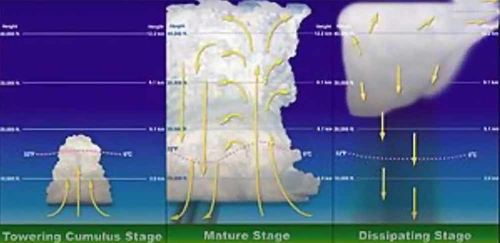
The updrafts of air that cause cumulonimbus clouds to form can also create turbulence. This is why these types of clouds are often avoided by pilots. If you are caught in a cumulonimbus cloud, it is best to descend to a lower altitude where the air is smoother.

Cumulonimbus clouds can be found all over the world and are most common in tropical regions. They typically form in the late afternoon when the sun heats the earth’s surface, creating rising columns of warm air. However, they can also form at night if there is sufficient heat from lightning or other sources. [1]
What Clouds Have the Greatest Turbulence?
Wind shear is one of the primary causes of turbulence. This occurs when there is a difference in wind speed or direction at different altitudes. The greater the difference, the greater the turbulence. Cumulonimbus clouds are often associated with strong wind shear, which can make them very turbulent.
Another cause of turbulence is thermal activity. This can occur when there are rising columns of warm air, as is often the case with cumulonimbus clouds. The rising air creates updrafts and downdrafts, which can be very turbulent.
How Are Cumulonimbus Clouds Formed?
Cumulonimbus clouds are thunderstorm clouds. They are very tall, dense, and full of water vapor. The lifting of air within the cumulonimbus cloud creates an updraft, which can be strong enough to sustain heavy rain or hail. Cumulonimbus clouds are usually accompanied by high winds, lightning, and thunder.
These massive storms tend to form in areas of low pressure where warm moist air is rising rapidly. As the air rises it begins to cool and condense into water droplets. The more the air rises, the cooler it gets, and the more water droplets form. Eventually, these droplets become too heavy to be carried by the updraft and they fall back down as rain.
The size and strength of a cumulonimbus cloud depend on how much moisture is available. If there is a lot of moisture in the air, the cloud can grow to be very large and produce heavy rain or hail.
Cumulonimbus clouds are most likely to form in the late afternoon or early evening when the sun has heated up the ground enough to create updrafts of warm air. However, they can also form overnight or in the early morning hours if there is an area of low pressure nearby.
While cumulonimbus clouds are often associated with severe weather, they can also produce beautiful skies. The clouds can be very tall, reaching heights of up to 15 kilometers (km). They are often white or gray in color and may have a flat base or be rounded at the top. Cumulonimbus clouds can also produce colorful sunsets as the sun sets behind them.
Why do cumulus clouds cause turbulence?
Cumulus clouds are large, fluffy clouds that form when warm air rises. The rising air creates an updraft, which can cause turbulence. The amount of turbulence depends on the strength of the updraft and the size of the cloud.
Cumulus clouds are often found in areas of unstable air, such as near thunderstorms. They can also form in areas of strong winds, such as at the leading edge of a cold front.
Which cloud types indicate convective turbulence?
The most well-known type of convective turbulence is clear air turbulence (CAT), which occurs when strong winds encounter obstacles such as mountains or large buildings. As the air flows around these obstacles, it can create powerful eddies and updrafts that can make flying conditions very difficult. CAT is most common in the vicinity of thunderstorms, but can also occur in other types of weather systems.
What clouds do pilots avoid?
There are a few different types of clouds that pilots generally avoid because they can cause turbulence. These include cumulonimbus clouds, also known as thunderstorms, and mammatus clouds.
Cumulonimbus clouds are large, vertical clouds that can extend up to 60,000 feet high. They are often accompanied by heavy rain, strong winds, hail, and lightning. Because of the dangerous weather conditions they can create, it’s best to avoid flying through cumulonimbus clouds if at all possible.

Mammatus clouds are another type of cloud that is best avoided by pilots. They are characterized by their bulbous shape and usually form after a thunderstorm has passed through an area. Although they don’t typically produce dangerous weather conditions, they can indicate that turbulence is likely in the area. [2]
What are nimbus clouds?
Nimbus clouds are a type of cloud that can produce precipitation. They are low-level clouds and are often associated with warm fronts. Nimbus clouds come in a variety of shapes and sizes, but they all have one thing in common: they are very turbulent.
The most common type of nimbus cloud is the cumulonimbus cloud, which is also the tallest and most turbulent type of cloud. Cumulonimbus clouds can reach heights of up to 16 kilometers (about ten miles) and can span hundreds of kilometers across. The largest cumulonimbus clouds on record are known as supercells, which can be up to 50 kilometers (about 30 miles) wide. Supercells usually form over land and can produce very large hail, strong winds, and tornadoes.
Do stratus clouds cause turbulence?
The short answer is no. Stratus clouds are generally very stable and don’t cause much turbulence. However, if you’re flying in or near a thunderstorm, you may experience some turbulence from the updrafts and downdrafts associated with the storm.
What visible signs indicate extreme turbulence in thunderstorms?
Where are cumulonimbus clouds found?
Cumulonimbus clouds are found in the tropics year-round, and in temperate regions during the summer months. They can be found at any time of day, but are most common in the late afternoon and early evening.
These clouds are often associated with severe weather, including thunderstorms, heavy rain, hail, and strong winds. If you see cumulonimbus clouds on the horizon, it’s important to be aware of the potential for severe weather and take appropriate precautions.
What season has the most turbulence?
The answer to this question is somewhat complicated. In the Northern Hemisphere, turbulence is more common in the late fall and winter, while in the Southern Hemisphere it peaks in the late spring and summer. But there are also regional variations. For example, turbulence is more common over the Rocky Mountains than elsewhere in North America.
There are a few factors that contribute to this seasonal variation. One is that the jet stream, which is a river of fast-moving air high in the atmosphere, tends to be wavier in winter than in summer. These waves can create areas of concentrated lift and downdrafts within them – perfect conditions for turbulence. Another factor is temperature differences between different parts of the atmosphere. In winter, cold air near the ground is often sitting beneath warmer air aloft. This temperature contrast can also create turbulence.
FAQ
Which type of cloud has the greatest turbulence?
The answer to this question largely depends on the specific conditions of the atmosphere at the time. However, in general, cumulonimbus clouds tend to be the most turbulent. These are the large, fluffy clouds that often accompany thunderstorms. The updrafts and downdrafts within these clouds can create strong turbulence.
Other types of clouds that can be turbulent are cumulus clouds, which are smaller and less fluffy than cumulonimbus clouds. They often form before thunderstorms as the atmosphere becomes unstable. Stratus clouds can also be turbulent if they are thick enough and have a strong enough wind blowing through them.
What clouds are turbulent?
The answer to this question is not as simple as it may seem. Turbulence can be caused by a variety of factors, including wind speed, temperature, humidity, and atmospheric pressure. In general, clouds that are high in the sky (above 20,000 feet) and have strong winds are more likely to be turbulent than other types of clouds.
Some of the most turbulent clouds include cumulonimbus clouds (thunderstorms), cirrus clouds (high-level wispy clouds), and stratus clouds (low-level sheets of cloud). However, turbulence can occur in any type of cloud, so it’s important to be aware of the conditions around you when flying in or near any type of cloud. [3]
Which clouds are not turbulent?
Non-turbulent clouds are generally found at lower altitudes, have sharp boundaries between the cloud and the sky, and are often described as “puffy” or “fluffy”. These clouds include cumulus congestus, cumulus humilis, and stratocumulus.
At higher altitudes, however, the air is colder and drier, so these types of clouds are not as common. Cirrus clouds are usually the only type of high-altitude cloud that is not turbulent. Cirrus clouds are often described as “wispy” or “feathery”. [4]
Useful Video: IFR Written Test Prep: Which clouds have the greatest turbulence?
Conclusion
So there you have it, everything you need to know about what clouds have the greatest turbulence. By understanding the causes of turbulence and how they relate to clouds, you can make better decisions about when to fly and when to avoid certain areas. Stay safe up there!
References:
- https://www.sophisticatededge.com/what-clouds-have-the-greatest-turbulence.html
- https://www.octalcomics.com/which-clouds-have-the-greatest-turbulence/
- https://bdjobstoday.info/what-clouds-have-the-greatest-turbulence/
- https://www.faa.gov/documentLibrary/media/Advisory_Circular/AC%2000-6A%20Chap%207-9.pdf